Comments (7)
 ThorTheDestroyer
commented on May 26, 2024
ThorTheDestroyer
commented on May 26, 2024
title: New USGS Lower Colorado San Bernard 2018 Lidar Data Release
author: Joey Thomas, StratMap
layout: news-article.njk
mainimage: https://s3.amazonaws.com/data.tnris.org/46b000dd-83b2-4701-b5c6-3f6e18cedccf/assets/34a0cde1-d679-411c-8ced-973143b93d26.jpg
thumbnail: https://tnris-org-static.s3.amazonaws.com/images/brown_missouri_th.jpg
thumbalt: A thumbnail for USGS 2018 Lidar Projects
abstract: A collaborative initiative to capture high-quality Lidar data for portions of west south central Texas.
The Texas Natural Resources Information System (TNRIS) is pleased to announce the release of about 17,942 square miles of recently acquired, high resolution lidar data over 26 counties in south central Texas. Aerial collection took place during the 2018 leaf-off season in Texas.
The project was funded by a federal consortium of partners to support the 3DEP mission, the Federal Emergency Management Agency (FEMA) Risk Mapping, Assessment, and Planning(MAP) program and the Natural Resources Conservation Service (NRCS) high resolution elevation enterprise program
Further details regarding this acquisition can be found by downloading the Project Report(s) found in the data catalog entry.
Data Access
To download the 2018 USGS Lower Colorado San Bernard lidar data products, please use the DataHub.
 Launch DataHub
Data coverage
Please see our Lidar status map for statewide lidar coverage.
Products
- Classified all-return lidar in LAS 1.4 format
- Bare-earth digital elevation model (DEM) in .img format (1-meter)
- Lidar intensity images in GeoTIFF format (1-meter)
- Hydro-flattening breaklines in SHP or Geodatabase
- Project-level FGDC metadata in XML
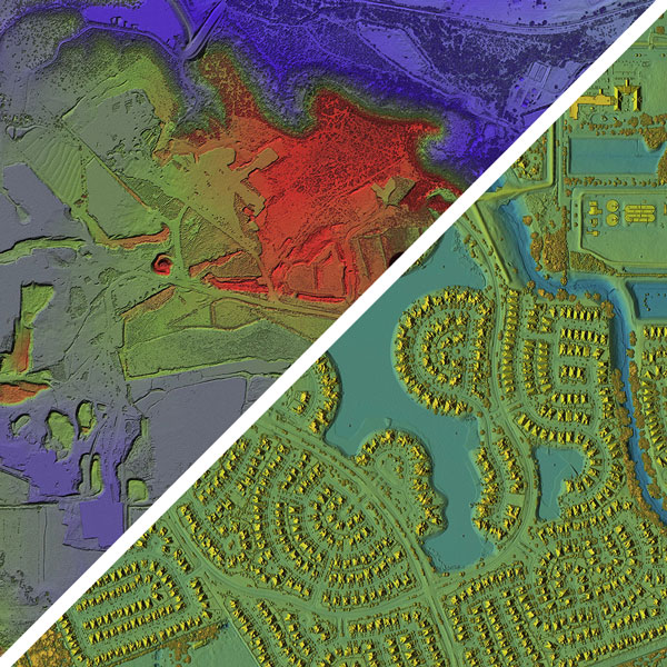
3-D Image of Lower Colorado San Bernard Lidar

3-D Image of Lower Colorado San Bernard Lidar

Product Specification
-
Vertical NVA RMSEz tested 4.9 cm . The tested accuracy in all areas meets the project specification for 10 cm.
-
Average first-return point density meets the 2 ppsm project specification.
-
Point data is classified according to the following American Society for Photogrammetry and Remote Sensing (ASPRS) class schema:
- Class 1: Unclassified
- Class 2: Ground
- Class 7: Low Point (noise)
- Class 9: Water
- Class 10: Ignored Ground
- Class 14: Culverts
- Class 17: Bridges
-
Projection Specifications
- Horizontal projection is UTM NAD83 (2011) Zone 14
- Vertical projection is NAVD88 Geoid 12B
- Units are in meters denoting orthometric heights
from tnris.org.
ThorTheDestroyer
commented on May 26, 2024
@christoball , tried to upload a .md and it said that format wasn't supported.
from tnris.org.
 christoball
commented on May 26, 2024
christoball
commented on May 26, 2024
@ThorTheDestroyer the comment will work fine
from tnris.org.
ThorTheDestroyer
commented on May 26, 2024

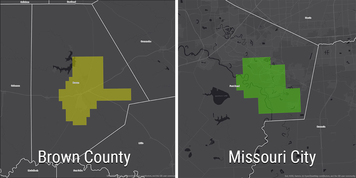
@christoball here is the coverage map.
from tnris.org.
christoball
commented on May 26, 2024
@ThorTheDestroyer Preview ready here:
http://haish.tnris.org/news/new-usgs-lower-colorado-san-bernard-2018-lidar-data-release/
from tnris.org.
ThorTheDestroyer
commented on May 26, 2024

@christoball the caption circle in the image need to change from "3D Lidar Point cloud" to "Bare Earth Digital Elevation Model"
Other than that, looks great.
from tnris.org.
christoball
commented on May 26, 2024
@ThorTheDestroyer I've gone ahead and made that change, will initiate the move to publish
from tnris.org.
Related Issues (20)
- Broken links on "latest data" on home HOT 1
- Lasted data featured home section- make width equalized HOT 4
- Featured data collections section on homepage fetches all collections from API instead of first three HOT 1
- Change urls from the "develop" branch to pull from "Development" HOT 4
- Update ESRI logo on Forum
- Add lunch info to forum agenda
- Carousel height fix HOT 5
- Move important sidebar content to main section on left (custom maps page) HOT 1
- Historical Imagery page updates HOT 1
- CTA cards on homepage fix HOT 2
- Broken link
- Add meta data in the head on forum 2023 pg HOT 3
- /stratmap/orthoimagery/ bottom the "lead-row" <p> juts out and looks awk -quick fix
- tnris.org/stratmap/ @ bottom where projects is the title and cards are not aligned, easy fix
- tnris.org/texas-imagery-service/ 1st paragraph text looks blurry/ too bold, not on theme w/ rest of site.. has text shadow that's why, I can take it off
- tnris.org/geographic-information-office/gis-solutions-group/
- on /applications-and-utilities/ the sidebar margin off @ top, fix to match the left side.
- Cross out "early bird" forum 2023 pg HOT 1
- Fugro logo update
- Add more context to buttons on 2024 forum pages
Recommend Projects
-
 React
React
A declarative, efficient, and flexible JavaScript library for building user interfaces.
-
Vue.js
🖖 Vue.js is a progressive, incrementally-adoptable JavaScript framework for building UI on the web.
-
 Typescript
TypeScript is a superset of JavaScript that compiles to clean JavaScript output.
-
TensorFlow
An Open Source Machine Learning Framework for Everyone
-
Django
The Web framework for perfectionists with deadlines.
-
 Laravel
A PHP framework for web artisans
-
D3
Bring data to life with SVG, Canvas and HTML. 📊📈🎉
-
Recommend Topics
-
javascript
JavaScript (JS) is a lightweight interpreted programming language with first-class functions.
-
web
Some thing interesting about web. New door for the world.
-
server
A server is a program made to process requests and deliver data to clients.
-
Machine learning
Machine learning is a way of modeling and interpreting data that allows a piece of software to respond intelligently.
-
Visualization
Some thing interesting about visualization, use data art
-
Game
Some thing interesting about game, make everyone happy.
Recommend Org
-
Facebook
We are working to build community through open source technology. NB: members must have two-factor auth.
-
Microsoft
Open source projects and samples from Microsoft.
-
Google
Google ❤️ Open Source for everyone.
-
Alibaba
Alibaba Open Source for everyone
-
D3
Data-Driven Documents codes.
-
Tencent
China tencent open source team.
from tnris.org.