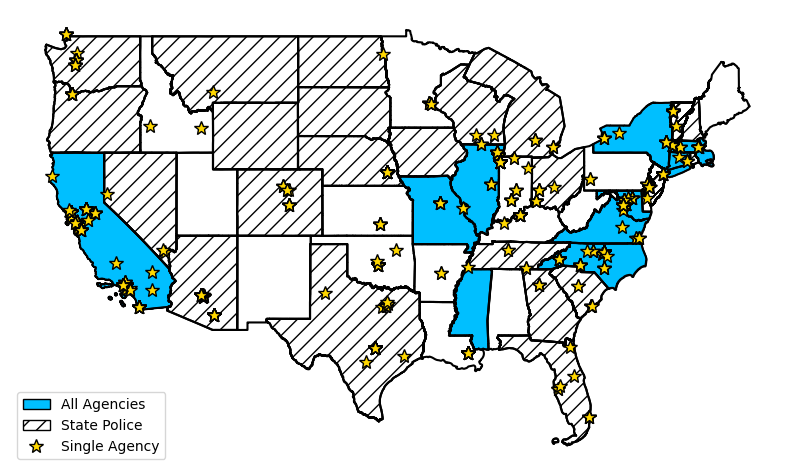
The OpenPoliceData (OPD) Python library is the most comprehensive centralized public access point for incident-level police data in the United States. OPD provides easy access to 425+ incident-level datasets for about 4850 police agencies. Types of data include traffic stops, use of force, officer-involved shootings, and complaints.
Users request data by department name and type of data, and the data is returned as a pandas DataFrame. There is no need to manually find the data online or to know how to work with open data APIs (ArcGIS, Socrata, etc.). When data is loaded by OPD, the returned data is unmodified (with the exception of formatting known date fields) from what appears on the source's site, and OPD provides links to the original data for transparency.
OpenPoliceData can be installed from the Python Package Index (PyPI):
pip install openpolicedata
OpenPoliceData provides access to police data with 2 simple lines of code:
> import openpolicedata as opd
> src = opd.Source("New Orleans")
> data = src.load(table_type="USE OF FORCE", year=2022)
NEW STARTING IN VERSION 0.6: OPD now provides tools for automated data standardization. Applying these tools allow you to start your analysis more quickly by replacing column names and data with standard values for some common column types. Learn how it works and how to use it here.
- Documentation: https://openpolicedata.readthedocs.io/
- Source Code: https://github.com/openpolicedata/openpolicedata
- Bug Tracker: https://github.com/openpolicedata/openpolicedata/issues
- Latest Datasets
- Release Notes
- Contributing
- Asheville, NC arrests, citations, complaints, incidents, pointing weapon, traffic stops, use of force, and 2023 calls for service
- Sacramento, CA 2024 calls for service, 2021-2024 incidents, and 2023-2024 citations
- Albemarle County, VA: Stops
- Norman, OK: Crashes, incidents, and traffic stops data (new) and most recent arrests, complaints and use of force data
- Oakland, CA: Stops
- Washington D.C.: Lawsuits against MPD
- Bloomington, IN: Use of Force and Citations
- Wallkill, NY: Employee and Stops
- Bremerton, WA: Arrests, Citations, and Incidents
- Phoenix, AZ: Officers Firearm Pointing
- Phoenix, AZ: 2024 Calls for Service
- Boston, MA: Deathes in Custody
- San Jose, CA: 2024 Calls for Service
- Portland, OR: 2024 Calls for Service
- Santa Monica, CA: 2022-2023 Incidents
- Added POINTING WEAPON (by officer) table type
- Added data loader to combine multiple files that span a single year into a single dataset
- Added support for more text date column formats in Arcgis loader.
- Added url_contains input to get_count, load_iter, load, and load_from_csv of Source class to distinguish between multiple datasets matching a data request
- Added datasets input to get_years to allow getting the years in specific datasets.
- Added Year Filter Guide to documentation
- Updates to standardization to handle more datasets
- Fixed year filtering for Tucson OFFICER-INVOLVED SHOOTINGS - INCIDENTS dataset. Datasets is no longer available using OpenPoliceData prior to Version 0.7.
Complete change log available at: https://github.com/openpolicedata/openpolicedata/blob/main/CHANGELOG.md
All contributions are welcome including code enhancments, bug fixes, bug reports, documentation updates, and locating new datasets. If you're interesting in helping out, see our Contributing Guide or reach out by email.


