Giter Club home page Giter Club logo

portal's Introduction

PORTAL - Planetary Terrain Models

Follow Twitter account for announcements. Twitter page HERE

You can produce your own terrain and download now. Visit PORTAL

Some of our partners

Simplex Spacesium

Watch video here :

Portal

tanitim.mp4

Features

  • Generate and preview for free
  • Multiple data source integration
  • Layered terrain structure to save both processing time and space
  • Free tools to serve on premise
  • Live preview on portal or sandcastle without coding
  • Download generated terrain

Please file an issue for any bugs or general questions. Email [email protected] for individual account questions

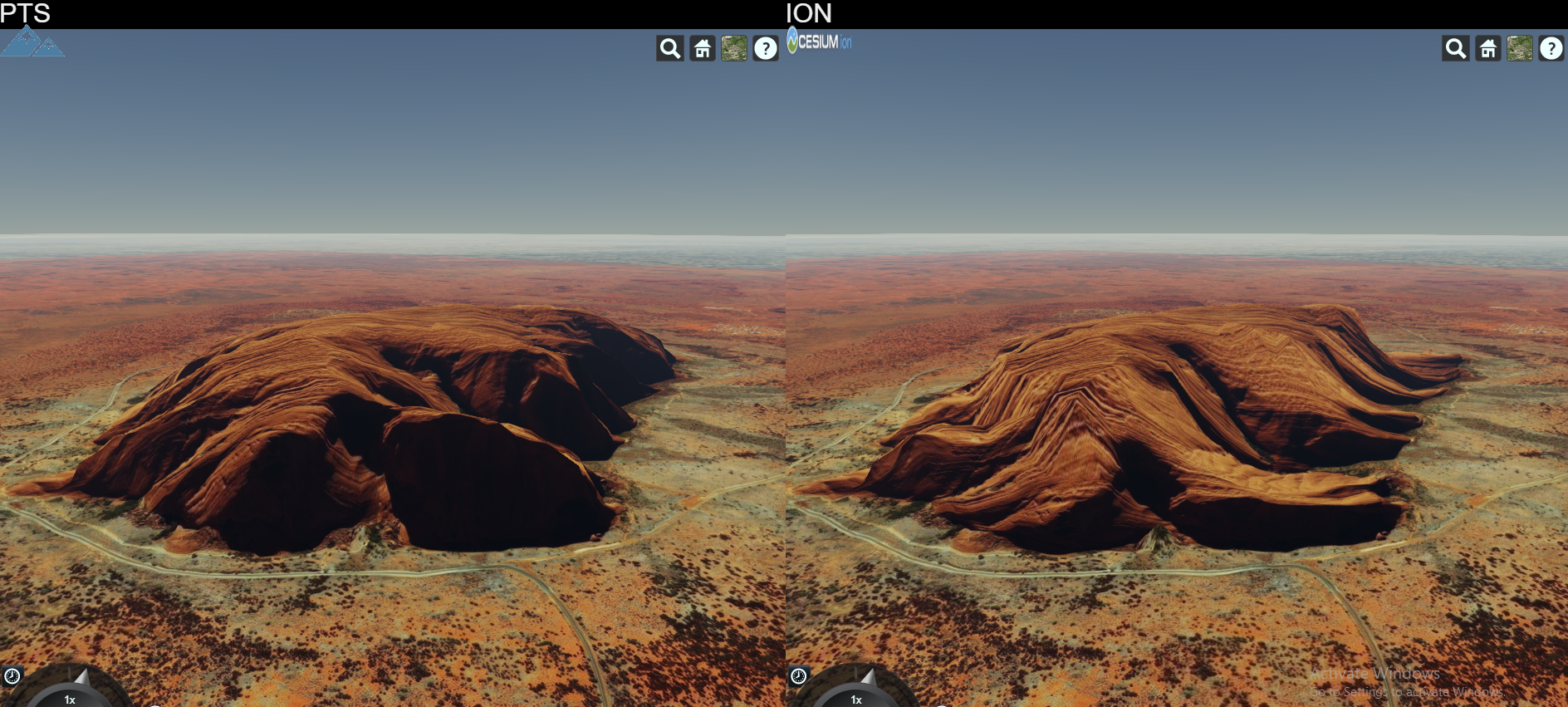
High Fidelity When Compared

PTSvsION

PTS is a software that produces terrain data to be served primarily for CesiumJS library.

Latest News (05.09.2019)

Cesium updated to 1.61. Now Earth looks way much cooler!

Preview1 Preview2

❗ High Resolution World Tileset is finally available. It has many data curated already and will be more incoming. Currently the coverage is stated as below:

  • 90 meters Antarctica
  • 90 meters Arctic Area
  • 90 meters above 60N Russia
  • 30 meters World Wide except above areas
  • 10 meters USA and Alaska
  • 10 meters Iceland
  • 10 meters Australia
  • 10 meters Norway
  • 8 meters New Zealand
  • 5 meters for Luxembourg

More will be joining to this high resolution dataset and improvements will be made.

❗ Vesta and Ceres asteroids are in 3D. Go to terrainserver.com to view them.

❗ First Tileset Released INFO

❗ World Tileset 90m whole world resolution is available for sale in order to support project. Lighting and Water extensions supported. Contact for details over Twitter. Preview HERE.

Features

  • Cesium ION output like terrain generation
  • Cesium STK Terrain Server dataset file format read support
  • Cesium STK Terrain Server dataset file format write support
  • Quantized Mesh format tile generation
  • KML format tile generation
  • Tile Lighting Support
  • Watermask Support
  • High Throughput Tile Server

Published Tile Sets

Releases

World High Resolution

High resolution whole world dataset. Extensions supported

World 90m

90m whole world dataset. Extensions supported

Beta versions

Mercury

665m resolution Mercury elevation data, original Mercury scale

Moon

118m resolution Moon elevation data, original Moon scale

Mars

232m resolution Mars elevation data, original Mars scale

Topo 15

Elevation and Bathymetry data for whole wide world in 500m resolution

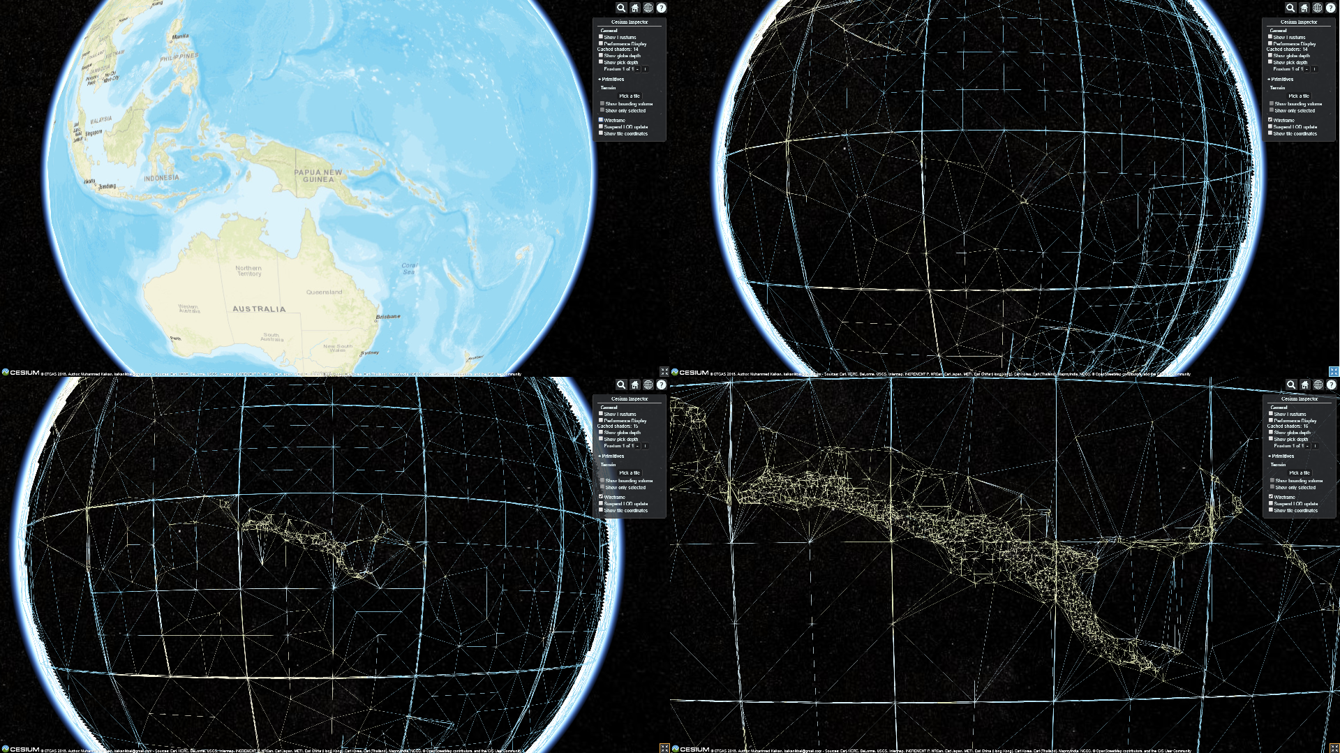
Quantized Mesh Rendered Papua

portal's People

Contributors

muhammedkalkan avatar

Stargazers

 avatar  avatar  avatar  avatar  avatar  avatar  avatar  avatar  avatar  avatar  avatar  avatar  avatar  avatar  avatar  avatar  avatar  avatar  avatar  avatar  avatar  avatar  avatar  avatar  avatar  avatar  avatar  avatar  avatar  avatar  avatar  avatar  avatar  avatar  avatar  avatar  avatar  avatar  avatar  avatar  avatar  avatar  avatar  avatar  avatar  avatar  avatar  avatar  avatar  avatar  avatar  avatar  avatar  avatar  avatar  avatar  avatar

Watchers

 avatar  avatar  avatar  avatar  avatar  avatar  avatar  avatar  avatar  avatar  avatar  avatar  avatar  avatar  avatar  avatar  avatar  avatar  avatar  avatar  avatar  avatar  avatar

portal's Issues

Emails are treated as spam, which is confusing

Hello,

This is issue is more of a reminder for you than anything. Currently, the emails sent from TGS end up in the SPAM folder (at least on my gmail).
So emails with the password and the download links are kind of lost.

Not very user-friendly, if you want your software to be usable

Fabien

Tile disappearance

Tiles disappear while looking from a particular angle. Clamped ground and upwards approx 30 degrees.

Interface to manage application

Interface implementation roadmap

  • Welcome page
  • Login page
    • Login
    • Register
    • Forget Password
  • Settings page
    • Memory limits
    • Processor limits
  • Datasets page
    • List datasets
    • Go to dataset
  • Dataset detail page
    • Add / Remove input sources
    • Other dataset properties (name,description..)
  • Tilesets page
    • List tilesets
    • Go to tileset
  • Tileset detail page
    • Ellipsoid selection
    • Output format selection
    • Add dataset functionality
    • Multitask progress and process functionality
    • Import tileset
    • View tileset

Input resources implementation

Input resources regulation

  • Introduce dataset and tileset concepts
  • Add missing properties of dataset
  • Add dataset to tileset transition implementations

Add an option to remember the user's password

Hello,

Passwords are sent by email, so the user doesn't chose it and it cannot be changed. Please automatically save the password, otherwise, you just have to find the email everytime you want to log in to TGS

Fabien

New data tile generation and merge

Roadmap for new tile generation and merging

  • Tile data merge operations
  • Watermask merge operations
  • Lighting calculation merge operations

Identification json implementation

Layers.json generation needs to be implemented

  • Tile Availability calculation
  • Supported extensions for tileset
  • Bounds of the tileset
  • Attribution of the tileset

Any new on the progress ?

I am very much interested in generating QMT from the DEM source. I see several initiatives, however no result yet. Can you specify when you plan to have beta version or something we could give a try ?

regards

ZS

Hope to get the quantizedMesh terrain

Greet job! I have established a terrain server with nodejs and mongoDB,but my terrain is heightmap,so can I use your tool to generate the QuantizedMesh terrain?If so,thanks a lot!

Where is the code?

Could you please clarify if this will be an open source project or commercial?

Instructions needed regarding how to use TGS

Hello,

We are looking into solutions to be able to use a custom TIFF file as elevation data in Cesium. It seems like you need a server to serve quatified meshes, which seem to be what this Github project is about.
I installed TGS and registered (fnicollet gmail com) but I don't really understand how it really works.

In the "Remote Databases" section, I clicked "Request" on "Gtopo30.terraindb". It didn't really do anything, the Request button is just greyed out (no download progress?).

In the "Local Databases" section, it seems like you can only add files with the "terraindb" extension. What are terraindb files exactly? How do you create them? I mean from "regular" GIS formats.

If I access the URL:

http://127.0.0.1:8080/

I get:

"Not Found /"

So I don't really know what URL I should put in my JS to be able to load a terrain from TGS. I think it should be something like

https://www.terrainserver.com/serveTerrain/world/layer.json

I tried a few combinations but nothing worked. What's the URL scheme here?

Also, I installed the online example (https://www.terrainserver.com) locally on my web server but I get errors because you don't have CORS headers:

Invalid asm.js: Invalid member of stdlib
localhost/:1 Failed to load https://www.terrainserver.com/serveTerrain/world/layer.json: No 'Access-Control-Allow-Origin' header is present on the requested resource. Origin 'http://localhost' is therefore not allowed access.
Cesium.js:523 An error occurred in "E": An error occurred while accessing https://www.terrainserver.com/serveTerrain/world/layer.json.

it would be nice to have this headers for testing.

It looks like your project is still in his early days, so it is probably all some documentation issues

Thanks for your help!
Fabien

Recommend Projects

  • React photo React

    A declarative, efficient, and flexible JavaScript library for building user interfaces.

  • Vue.js photo Vue.js

    🖖 Vue.js is a progressive, incrementally-adoptable JavaScript framework for building UI on the web.

  • Typescript photo Typescript

    TypeScript is a superset of JavaScript that compiles to clean JavaScript output.

  • TensorFlow photo TensorFlow

    An Open Source Machine Learning Framework for Everyone

  • Django photo Django

    The Web framework for perfectionists with deadlines.

  • D3 photo D3

    Bring data to life with SVG, Canvas and HTML. 📊📈🎉

Recommend Topics

  • javascript

    JavaScript (JS) is a lightweight interpreted programming language with first-class functions.

  • web

    Some thing interesting about web. New door for the world.

  • server

    A server is a program made to process requests and deliver data to clients.

  • Machine learning

    Machine learning is a way of modeling and interpreting data that allows a piece of software to respond intelligently.

  • Game

    Some thing interesting about game, make everyone happy.

Recommend Org

  • Facebook photo Facebook

    We are working to build community through open source technology. NB: members must have two-factor auth.

  • Microsoft photo Microsoft

    Open source projects and samples from Microsoft.

  • Google photo Google

    Google ❤️ Open Source for everyone.

  • D3 photo D3

    Data-Driven Documents codes.