Giter Club home page Giter Club logo

pinpoi's Introduction

PinPoi

PinPoi

PinPoi imports thousand points of interest for your GPS navigator in your Android phone.

You can import Google KML and KMZ, TomTom OV2, simple GeoRSS, Garmin GPX, Navigon ASC, CSV and zipped collections directly into your phone and organize them in collections.

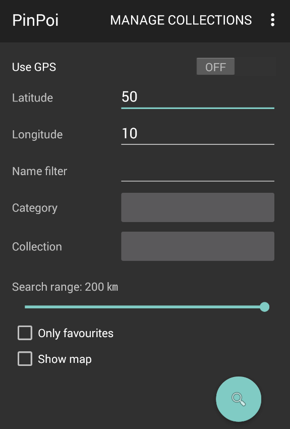
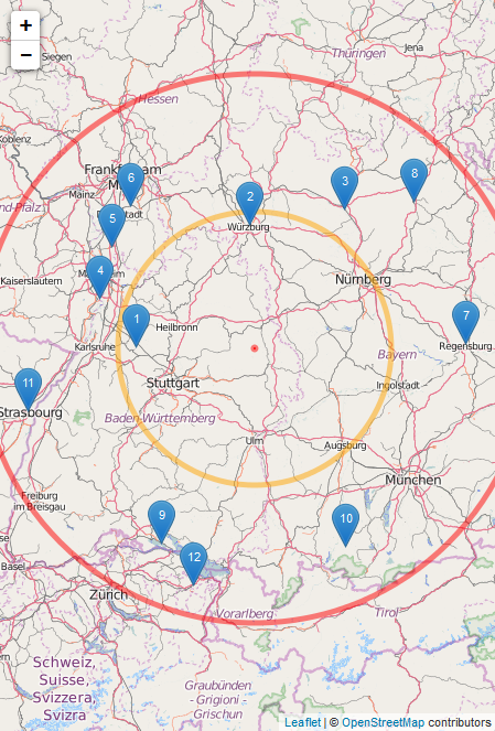
PinPoi searches using your GPS position or a custom location (location address or Plus Code), you can choose your destination from a map and open it with your preferred app.

Main screen POI map

Features and more screenshots https://fvasco.github.io/pinpoi/

Install

Download and install APK https://f-droid.org/repository/browse/?fdid=io.github.fvasco.pinpoi (no registration required)

Install APP using Google Play https://play.google.com/store/apps/details?id=io.github.fvasco.pinpoi (Google account required)

Donate

Do you like PinPoi or do you wish a better one?

Pinpoi is free, offer me a fruit juice ;)

Donate

Language: Kotlin

pinpoi's People

Contributors

akintunde102 avatar danielecapursi avatar fvasco avatar naofum avatar xinxinxinxinxin avatar

Stargazers

 avatar  avatar  avatar  avatar  avatar  avatar  avatar  avatar  avatar  avatar  avatar  avatar  avatar  avatar  avatar  avatar  avatar  avatar  avatar  avatar  avatar  avatar  avatar  avatar  avatar  avatar  avatar

Watchers

 avatar  avatar  avatar  avatar  avatar

pinpoi's Issues

map not load

when selected "view map" on in italian "visualizza mappa" after the tap in find buttom only white screen and the floating notification whit number of waypoint finded.
i have a Zenfone5.
thanks

Add importer for womo data

Create import script (Python or Java language) to analyze, parse and import womo data from external sources.

as user I'd like to see different color markers on map so that I can easily understand how many they are of the same collection/category

When you see al the markers on the map they are all blue with a number on it, would be fine if they are of the same category/collection.

Having coloured collections or categories IMO can help understanding how many markers are the same.

I think having a randomly assigned colour may be enough for start, otherwise a full feature would allow to choose the colour during creation/editing

Map is in local language

The map is displayed in the local language.
I don't know every language in the world so I can't read the place names for most of the world :-(

Add icon to F-droid

There is nice and documentation for it, you just have to create folder structure for it lets say with fastlane and in next release it gets updated automatically

Just idk about #38 and where is icon

The app doesn't ask for storage access

Hello,
I'm having issues to add pois in the app.
The app doesn't have access to the storage of the phone, so impossible to add any pois in a collection.
Even in the settings, in the permission manager, I can't allow PINPOI to have access to the storage.
I have this error on the phone (Samsung Galaxy A32) when I click on the file I want to add :
Mime-Type: application/octet-stream

Do you have any idea how to solve that ?
Thank you very much

Update all categories at once

Not really an issue but an annoyance bothering me for a long while. I would like to update all pois for all categories at once instead off doing this per category separately. I've a large number of pois and categories.
Can this option be provided pls?

Can't import exported KMZ from Organic Maps

Hi

I tried to import a KMZ file exported from Organic Maps but this results in an error in PinPoi saying the file contains no POI.

Steps to reproduce

  • add some POIs in Organic Maps app
  • export those POIs ("export as a file" from context menu of POIs group in app
  • import this file onto PinPoi

Thanks !

Use a proper map library?

OsmDroid is a library that can show markers on a slippy map. This is

  • faster, and better security-wise, than downloading JS from unpkg
  • more maintainable than hard-coding html or generating html at runtime
  • has neat features: auto-groups markers based on the zoom, shows current location, ...
  • enables future support for customizing the basemap, showing tracks, ...

Dialog disappears on device rotation

When i perform these sequences of events, the dialog on screen disappears:

Sequence 1:

  1. Click on Search Address
  2. Orientation Change

Sequence 2:

  1. Click on Category
  2. Orientation Change

Sequence 3:

  1. Click on Search Address
  2. Enter Address and wait for result
  3. Orientation Change

KML importer

Create a Keyhole Markup Language importer as datasource.

Add yandex.[maps/navigator] and 2gis support

Hello, I'd like to have a cross-application or above-application manager for geographical coordinates.
As far as I understand - that's what your application does (I just stumbled upon it in the F-Droid repo), but unfortunately it doesn't support neither 2GIS nor Yandex.Maps/Navigator map apps.
Could you, please, add support of them?

Odd copy'n'paste behaviour

From [Manage collections], editing one collection, it is possible to long-press select the address but the cut/copy/paste dialog is absent.
It is possible to drag the address into the [description] field where the cut/copy/paste dialog is present

Crash when displaying map

(edited) I get this whenever I try to open the builtin map on a GPX of 1500 points. The map shows up in the background while loading, but the loading never finishes, then the app crashes.

With another smaller category, the map shows and the app does not crash.

FATAL EXCEPTION: main
Process: io.github.fvasco.pinpoi, PID: 2884
android.view.WindowManager$BadTokenException: Unable to add window -- token android.os.BinderProxy@acde074 is not valid; is your activity running?
	at android.view.ViewRootImpl.setView(ViewRootImpl.java:922)
	at android.view.WindowManagerGlobal.addView(WindowManagerGlobal.java:377)
	at android.view.WindowManagerImpl.addView(WindowManagerImpl.java:105)
	at android.widget.Toast$TN.handleShow(Toast.java:746)
	at android.widget.Toast$TN$2.handleMessage(Toast.java:622)
	at android.os.Handler.dispatchMessage(Handler.java:102)
	at android.os.Looper.loop(Looper.java:154)
	at android.app.ActivityThread.main(ActivityThread.java:6816)
	at java.lang.reflect.Method.invoke(Native Method)
	at com.android.internal.os.ZygoteInit$MethodAndArgsCaller.run(ZygoteInit.java:1563)
	at com.android.internal.os.ZygoteInit.main(ZygoteInit.java:1451)

Version 1.10.4 on Samsung Android 7.1.

Confusing loading state in Battery Saver

Dear developer,

I noticed that when I enable Battery Saver on Android 8.1, the indeterminate ProgressBars in the app are not properly shown. This is a known problem in Android API level <28, see e.g. this StackOverflow question. Battery Saver disables animations, also on progress bars on these versions. This is quite confusing because the loading state is not properly represented. It is fixed in later Android versions, where progress bars do appear and animate.

Looking at the code, indeterminate progress bars are created here:

className='io.github.fvasco.pinpoi.util.ProgressDialog', lineNumber=35

To fix this issue, one can check ValueAnimator.areAnimatorsEnabled() and provide a different UI element, such as a text label, when animations are disabled.

I also recorded a video, showing the issue in practice:

io.github.fvasco.pinpoi.mov

Collection or category in marker popup

As user I would like to read the poi's category or collection name in marker on map so that I can easily understand what's related if Poi name is not clear

Create Android base application

Create basic Android application with:

  • TableView Activity where user can switch from ListView to MapView and viceversa.
  • Add ButterKnife dependency to Gradle settings.

RFE: `GeoJSON` format

One of my uses for PinPoi is with map surveying.

In the OSM realm, GeoJSON is a commonly-used format.

Sometimes, a dataset isn't published (or a tool doesn't output) in any format which PinPoi can parse (i.e. only GeoJSON).

Thus, it would be most helpful to use this format in PinPoi.

grpc failed

When searching an address/location pinpoi returns "GRPC failed" when trying to geolocate the address and on is unable to search on address anymore.

no issue

(Not PinPoi's fault, sorry for the noise.)

Instructions

Hi,
Are there any instructions for this app?
I'm not clear what this app does & I have no idea how to make it do whatever it does

no issue

When the search button is tapped and show on map is checked, why does the app connect to the developer's domain fvasco.github.io? An app that accesses the location and points of interest should not do unnecessary network connections to a website that may be compromised etc.

The f-droid issue is here

Error on my part, see below

Error message : Please Check the values

Hello,
Thank you for this software, it is really usefull.
In my company, we have been using it for a couple of years without any issue.

But today, on a new smartphone, I have placed the *ov2 files on a smartphone, and then, when a research is launched, I get the following message : Validation Error, please check the value.

It is strange beacause our data files is still the same for weeks and weeks.
I wonder if the problem comes from the new Android 10 version on Samsung A40.

Import dialog text

In English, having downloaded a collection, there is a menu option to [rename]. The dialog this produces has [no] & [yes] buttons. I would have expected these to be [cancel] & [ok]

Recommend Projects

  • React photo React

    A declarative, efficient, and flexible JavaScript library for building user interfaces.

  • Vue.js photo Vue.js

    ๐Ÿ–– Vue.js is a progressive, incrementally-adoptable JavaScript framework for building UI on the web.

  • Typescript photo Typescript

    TypeScript is a superset of JavaScript that compiles to clean JavaScript output.

  • TensorFlow photo TensorFlow

    An Open Source Machine Learning Framework for Everyone

  • Django photo Django

    The Web framework for perfectionists with deadlines.

  • D3 photo D3

    Bring data to life with SVG, Canvas and HTML. ๐Ÿ“Š๐Ÿ“ˆ๐ŸŽ‰

Recommend Topics

  • javascript

    JavaScript (JS) is a lightweight interpreted programming language with first-class functions.

  • web

    Some thing interesting about web. New door for the world.

  • server

    A server is a program made to process requests and deliver data to clients.

  • Machine learning

    Machine learning is a way of modeling and interpreting data that allows a piece of software to respond intelligently.

  • Game

    Some thing interesting about game, make everyone happy.

Recommend Org

  • Facebook photo Facebook

    We are working to build community through open source technology. NB: members must have two-factor auth.

  • Microsoft photo Microsoft

    Open source projects and samples from Microsoft.

  • Google photo Google

    Google โค๏ธ Open Source for everyone.

  • D3 photo D3

    Data-Driven Documents codes.