Giter Club home page Giter Club logo

landslide-mapping-with-cnn's Introduction

A new strategy to map landslides with a generalized convolutional neural network

Code repository for https://www.nature.com/articles/s41598-021-89015-8

DOI

NOTE: The file "M_ALL_006.hdf5" is the trained TensorFlow model.

A typical machine learning workflow involves creating a small inventory manually to train a supervised model, which is further used to map landslides in the surrounding areas of interest. This saves a lot of time and effort, however, it is still not suitable for a fully automated rapid mapping scenario as human intervention is required for creating the initial training inventory.

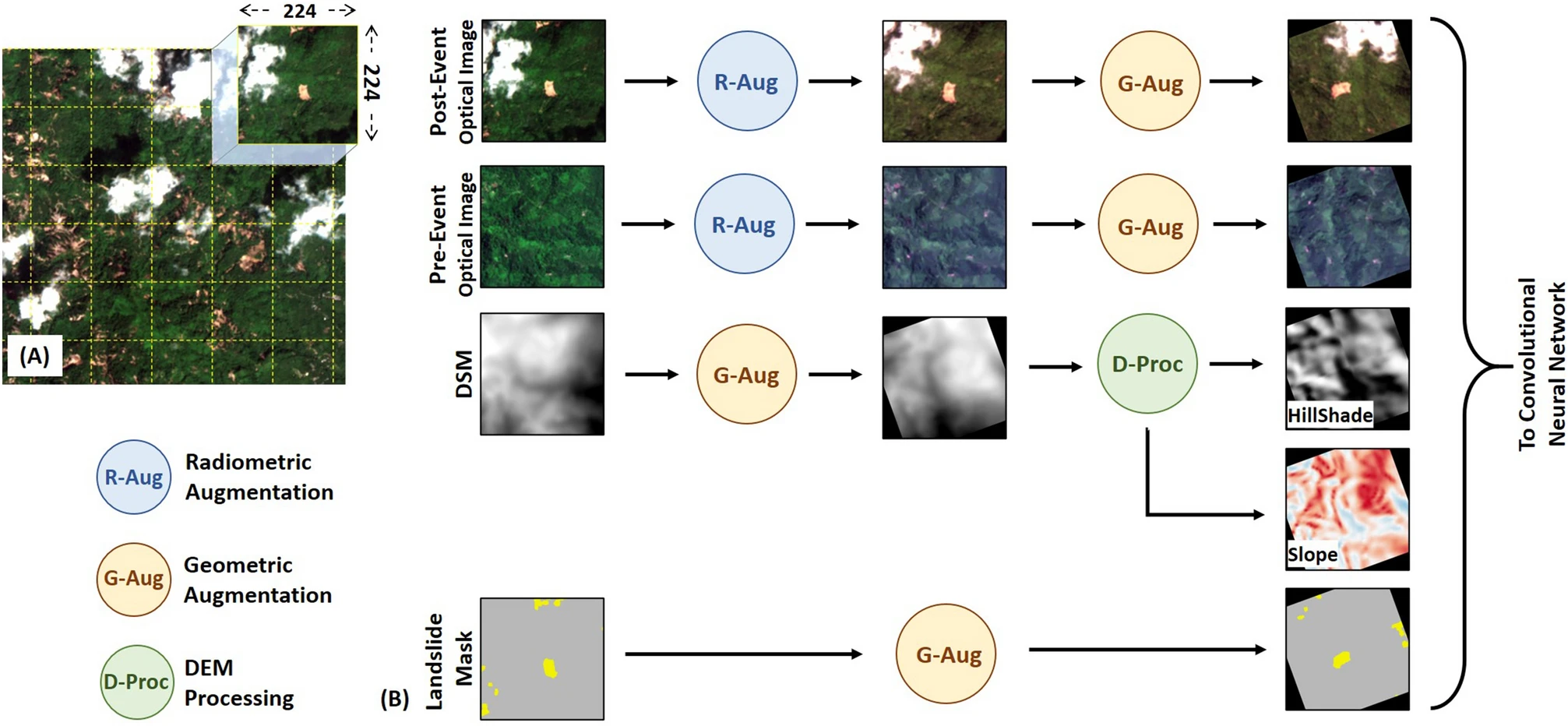
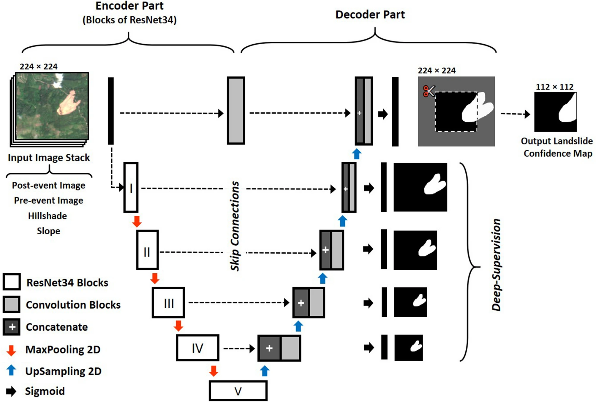
This repository shares a generalized deep-learning model which can be used to map landslides triggred by large earthquakes or extreme rainfall events. It can be used on medium resolution EO data (resolution: 5 - 10 meters, like Sentinel-2, Rapid-Eye, etc). It can be used directly without training for a specific event / georgaphic location.


Pre-processing workflow Figure: Pre-processing workflow adopted for training of CNN. (A) Systematic tiling of input images with 50% overlap. In this study , a tile size of 224ร—224 was used as an input to the CNN. The tile size in display is for representation purposes and does not scale to the actual base resolution used in training the CNN. (B) Steps involved in the data-augmentation of input images with their corresponding landslide mask.


overview of proposed U-Net architecture Figure: An overview of proposed U-Net architecture with residual blocks and deep-supervision. The complete description of all the layers in the network is available in Supplementary-Figure Folder.


Upcoming in IGARSS 2021 Conference

Mapping landslides caused by Storm Alex, October - 2020 (French-Italian Alps)

Result of landslide triggred by Storm Alex

Result of landslide mapping. (A) The density map showing the distribution of induced landslides identified by the generalized CNN. (B) - (E) Multiple views from the study area showing changes observed in Sentinel-2 images from before and after the triggering event. The landslides identified by the CNN has been marked as red polygons in the post-event images. Figure (E) is an example of false-positive detection due to cloud shadow, which was not identified by the Fmask algorithm.

landslide-mapping-with-cnn's People

Contributors

nprksh avatar

Recommend Projects

  • React photo React

    A declarative, efficient, and flexible JavaScript library for building user interfaces.

  • Vue.js photo Vue.js

    ๐Ÿ–– Vue.js is a progressive, incrementally-adoptable JavaScript framework for building UI on the web.

  • Typescript photo Typescript

    TypeScript is a superset of JavaScript that compiles to clean JavaScript output.

  • TensorFlow photo TensorFlow

    An Open Source Machine Learning Framework for Everyone

  • Django photo Django

    The Web framework for perfectionists with deadlines.

  • D3 photo D3

    Bring data to life with SVG, Canvas and HTML. ๐Ÿ“Š๐Ÿ“ˆ๐ŸŽ‰

Recommend Topics

  • javascript

    JavaScript (JS) is a lightweight interpreted programming language with first-class functions.

  • web

    Some thing interesting about web. New door for the world.

  • server

    A server is a program made to process requests and deliver data to clients.

  • Machine learning

    Machine learning is a way of modeling and interpreting data that allows a piece of software to respond intelligently.

  • Game

    Some thing interesting about game, make everyone happy.

Recommend Org

  • Facebook photo Facebook

    We are working to build community through open source technology. NB: members must have two-factor auth.

  • Microsoft photo Microsoft

    Open source projects and samples from Microsoft.

  • Google photo Google

    Google โค๏ธ Open Source for everyone.

  • D3 photo D3

    Data-Driven Documents codes.